

Crop Monitoring Plataform

Drone service

Identification of subsurface anomalies

Identification of water resources
Geophysics

Bathymetry

High-resolution satellite imagery

Advanced soil moisture mapping
Crop Monitoring Plataform
Drone service
Identification of subsurface anomalies
Identification of water resources
Geophysics
Bathymetry
High-resolution satellite imagery
Advanced soil moisture mapping

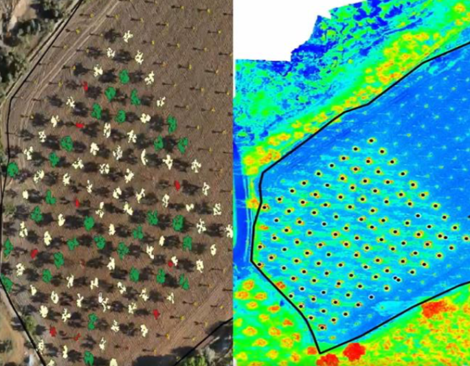
Through the use of satellite imagery, we help farmers manage multiple fields, reduce costs, optimize resources, and make decisions. This technology allows, for example, the measurement and control of water stress and pest monitoring
Expected outcomes:


4 pillars


NDVI: Allows the prompt response to issues by quickly identifying problematic areas within the field at the different stages of plant growth.

NDRE: Estimates nitrogen concentrations in plant leaves halfway through and at the end of a season.

ReCI: Photosynthetic activity of the vegetation covering sensitive to chlorophyll content in leaves.

MSAVI: Determines the presence of vegetation in early development stages.

NDMI: Shows the level of crop water stress.

Elevation and slope maps.

Seasonal analysis.

Field activity control.

14-day weather forecast and weather station control.


Through flights with a high-end drone, we support agricultural and forestry producers in different stages of their production processes, focusing on improving their productivity.
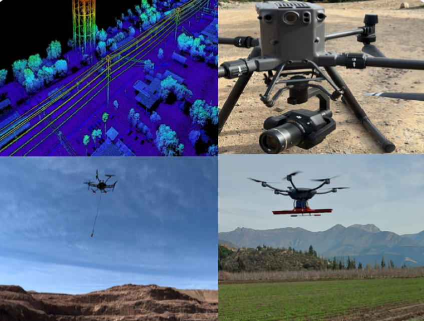
Through flights with a high-end drone, we support the industry in different stages of their processes.
Flights with a high-end drone carrying a GPR (Ground Penetrating Radar) geophysical system, which allows the detection of aquifers (groundwater) and underground bodies such as pipes, rocks, etc. It also makes it possible to detect anomalies such as leaks in ponds, pipes, and tanks. This technology allows for a subsurface measurement of up to 120 meters deep.

In the attached image, we can observe our results. A 3D model of the identified aquifers with a range of up to 120 meters deep.

Bathymetry service consists of a topographic survey of the relief of surfaces covered by water, whether it be the seabed or the bottoms of rivers, wetlands, lakes, reservoirs, tanks, etc. This allows, for example, the calculation of the actual volume of water in tanks, where there may be a loss of volume due to sedimentation and/or leaks.


Satellite observation images that allow searching, processing, and obtaining valuable information on the go from satellite data to address real business problems with more precise, reliable, and timely data.
Images of 15, 30, and 40 centimeters per pixel.
Through the application of proprietary algorithms, it is possible to develop effective and accurate models for analyzing soil moisture. The resulting soil moisture maps, both at the surface and at the root level, can be used for daily monitoring, precise yield estimation, and the study of significant climatic trends.

Surface soil moisture (0-7cm).

Soil moisture in the root zone (up to 70cm deep).

Available within six hours after satellite pass.

250m resolution for large-scale data analysis.

Historical data since 2002 and daily updates.

Not affected by clouds or vegetation.

Global revisit daily or every 2 or 3 days (depending on the satellite).
