

Satellite services
forest

Wildfire detection system

Forest Monitoring plataform

Drone service

Identification of subsurface anomalies

Identification of water resources
Geophysics

Bathymetry

High-resolution satellite imagery
Satellite services
Forest
Wildfire detection system
Forest Monitoring plataform
Drone service
Identification of subsurface anomalies
Identification of water resources
Geophysics
Bathymetry
High-resolution satellite imagery
Satellite services
Forest
Wildfire detection system
Forest Monitoring plataform
Drone service
Identification of subsurface anomalies
Identification of water resources
Geophysics
Bathymetry
High-resolution satellite imagery
We use satellite services to detect changes in the forest with the greatest possible precision. The interval between checks is two weeks or more, depending on request. Machine learning technologies can also be employed to optimize cost and time efficiency.
Forest-covered areas are green on the map, while all other land uses (roads, fields, etc.) are labeled under "Others" and are gray in color.


We use our EOS SAT-1 satellite or any other complementary satellite to detect changes in the forest with the greatest possible precision. The interval between checks is two weeks or more, depending on request. We can employ machine learning technologies to optimize cost and time efficiency.


SWIR band penetrates through smoke and haze, allowing the fire source to be located.
Service per event.

Wildfires are the most dangerous enemy of the forest, bringing harmful and devastating consequences. Preventing and controlling wildfires is an effective way to improve fire prevention efficiency.
Dual-sensor hot spot detection cameras have been developed based on the state-of-the-art technology. An integrated intelligent analysis module, a hot spot detection algorithm, can automatically detect flames from long distances, vehicles, personnel, and other heat source targets (over 10 kilometers).


Remote precision forestry monitoring and evaluation in all regions and within each forest stand.
Monitoring of forest fires based on NASA's FIRMS technology for abnormal high-temperature alerts (thermal anomaly map).
Regional-scale satellite monitoring of deforestation within forest stands.
Control plant moisture content and reduce the risk of tree diseases and forest fires with reports on water stress.

Improved planning of forestry operations thanks to reliable weather forecasting in a 9km2 area.
Make better decisions and study weather trends in your area of interest with historical weather data available since 2008.
Find the correlation between weather trends and forest growth based on the sum of active temperatures for a specific period.
Predict forest fire risk situations based on historical weather data, such as accumulated precipitation and temperature trends

Track changes in as many forest stands as you want.
Analyze changes in your forest stands on a monthly, quarterly, or annual basis and download reports in *.pdf and *.xls formats.
Take wildfire management to a new level with the high-temperature alert system.
Adjust notifications to your specific needs and stay informed of any changes in forest productivity, water stress, and other parameters.


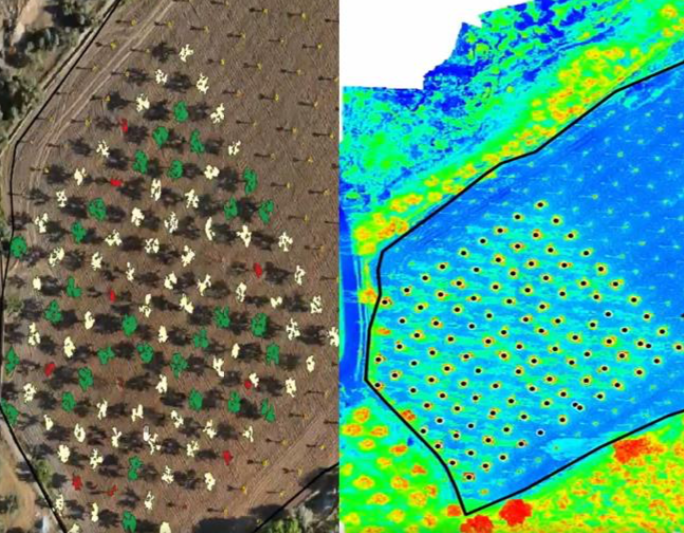
Through flights with a high-end drone, we support agricultural and forestry producers in different stages of their production processes, focusing on improving their productivity.
The drone service allows monitoring and control of weeds in forests, focusing on forest health and fire control.
Through flights with a high-end drone, we support the industry in different stages of their processes.
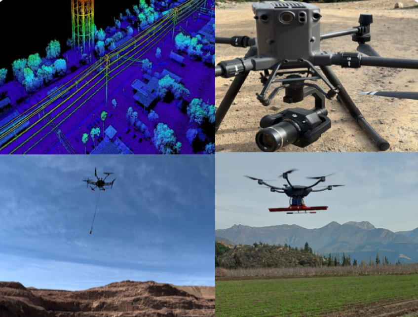
Flights with a high-end drone carrying a GPR (Ground Penetrating Radar) geophysical system, which allows the detection of aquifers (groundwater) and underground bodies such as pipes, rocks, etc. It also makes it possible to detect anomalies such as leaks in ponds, pipes, and tanks. This technology allows for a subsurface measurement of up to 120 meters deep.

In the attached image, we can observe our results. A 3D model of the identified aquifers with a range of up to 120 meters deep.

Bathymetry service consists of a topographic survey of the relief of surfaces covered by water, whether it be the seabed or the bottoms of rivers, wetlands, lakes, reservoirs, tanks, etc. This allows, for example, the calculation of the actual volume of water in tanks, where there may be a loss of volume due to sedimentation and/or leaks.

Satellite observation images that allow searching, processing, and obtaining valuable information on the go from satellite data to address real business problems with more precise, reliable, and timely data.
Images of 15, 30, and 40 centimeters per pixel.
